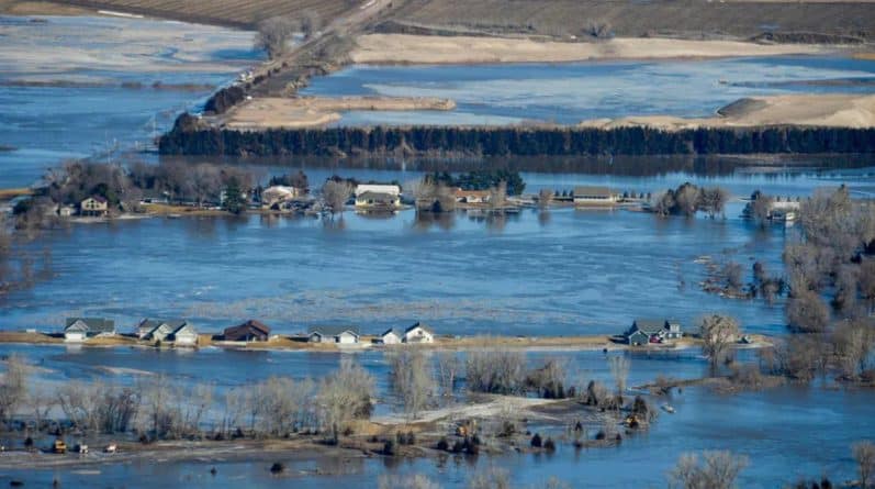
Nebraska continues to battle the largest in its history, the flood.
 Source: Nebraska National Guard
Last week, the «bomb cyclone» struck the Midwest, bringing heavy rains to the territory from Texas to Minnesota.
Due to the fact that the soil is not sufficiently warmed to quickly absorb water, started flooding, and river in the basins of the Mississippi and Missouri flooded. The main blow fell on Nebraska and Iowa, killing at least three people, a few are still missing.
Current #Flood2019 conditions at Waterloo near 228th & Dodge. #NebraskaStrong #Nebraska #NebraskaFlood2019 pic.twitter.com/PHAJhGUbua
— NSP Trooper Cook (@NSPTrooperCook) March 18, 2019
To understand the scale of the floods, NASA has posted a satellite image taken about Omaha (Nebraska) in March 2018 and March 16 this year.
 Source: NASA
Representatives of the state patrol of Nebraska reported that on Saturday morning, the bridge on State Route 92 crossing the Elkhorn river West of Omaha, was swept away by flood waters.
According to the report of the emergency management Agency of Nebraska (NEMA), about 2,000 evacuees are now in 22 shelters the American red cross. The city of Fremont, in fact, has become an island as all departures from it flooded.
On Monday in the Eastern part of the state closed many roads, including interstate 29 between Omaha (ne) to the Rock Port (mo).
In the Eastern part of the state closed almost all schools, and the loss of electricity due to the floods had forced the city of Lincoln, to introduce restrictions on water use.
«This is really the most destructive flood in the history of our state», — said yesterday, on March 18, the Governor of Nebraska Pete Ricketts.
